1939 hat Bernard H. Porter die optimale Fusion aus Geografie und Physik erschaffen:
„[A] map of physics, containing a brief historical outline of the subject as will be of interest to physicists, students, laymen at large; Also giving a description of the land of physics as seen by the daring sould who venture there; And more particularly the location of villages (named after pioneer physicists) as found by the many rivers; Also the date of founding of each village; As well as the date of its extinction; and finally a collection of various and sundry symbols frequently met with on the trip.“
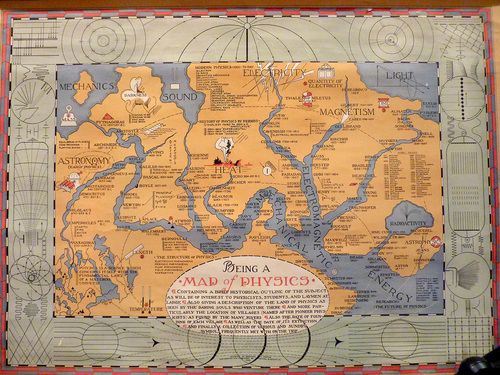
Wirklich cool! Da würde ich gern mal Urlaub machen. Eine kleiner Wanderung von der Astronomie ganz im Westen bis hin zur Astrophysik im Westen und dann an Herschel, Newton und Ptolemäus an den Lichtstrand und ein wenig entspannen 😉
Eigentlich fehlen nur noch 2 Dinge: Eine hochauflösende Version dieser Karte, damit man sie als Poster für die Wand ausdrucken kann. Und eine aktualisierte Version, die die Entwicklung der Physik seit 1939 inkludiert. Seit damals haben die Wissenschaftler ja jede Menge Neuland entdeckt!